
River Ward Candidate Michael Kostiuk proposes O-Train Extension to EY Centre and Ottawa Airport
Problem: How to extend Light Rail Service to the Airport south of the Greenboro O-Train Station. Since the EY Centre is near the Airport I also wanted to investigate whether this site could also be effectively served by a southward extension of the O-Train.
I have looked at this problem through my training as a geographer, and my extensive local knowledge. I have used a variety of methods such a physically walking through various areas in and around the airport lands, using aerial imagery, creating maps on various possible routes, and consulting local transit advocates.
My goal was to investigate what route is the most practical and cost effective route that could serve the various sites that occupy the areas in and near the Ottawa Airport Lands. I also wanted to look at routes that had the least amount of road crossing.
Note: The options shown are not based on detailed engineering or environmental studies, but rather, they are to serve as a discussion point on what might be possible future routes to investigate for future O-Train Service to the Ottawa Airport lands. That is why I have titled this a “Concept”.
Note: The Trap of Using Existing Railway Corridors/Tracks.
One of the many benefits of using existing railway lines for Light Rail is that tracks and other railway infrastructure are already in place. Sometimes there is even grade separation in the form of bridges and underpasses in place. However, just because there is an existing Railway Corridor available, that does not mean that we should ONLY be using that one existing route. The original route was chosen for a transportation purpose (such as freight or inter-city passenger rail) and it may not be useful for future Light Rail use if it does not serve places where transit users need to go.
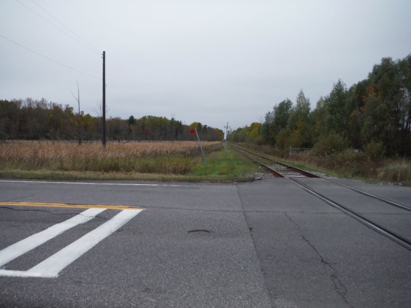
The following images show the existing rail corridors on both sides of Lester Road. Note that it passes through vacant bush and swap land and it does not serve any local transit need in this location.
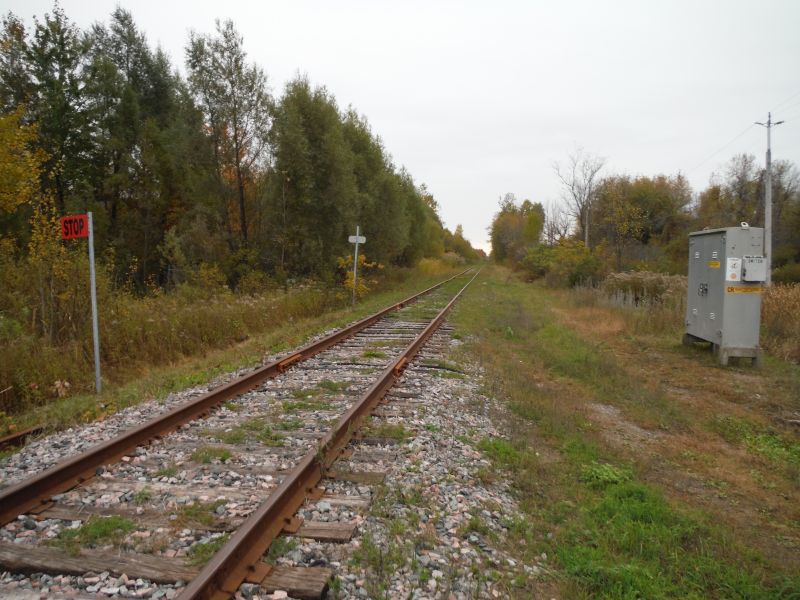
The goal of this exercise is to investigate how adding a line to the west and closer to the Airport lands is a better and more cost effective use of Light Rail. The Light Rail trains used in this location can be in the form of Diesel Light Rail as in the case of the existing O-Train or electrical.
The following image is a map that shows many of the various routes that I investigated.
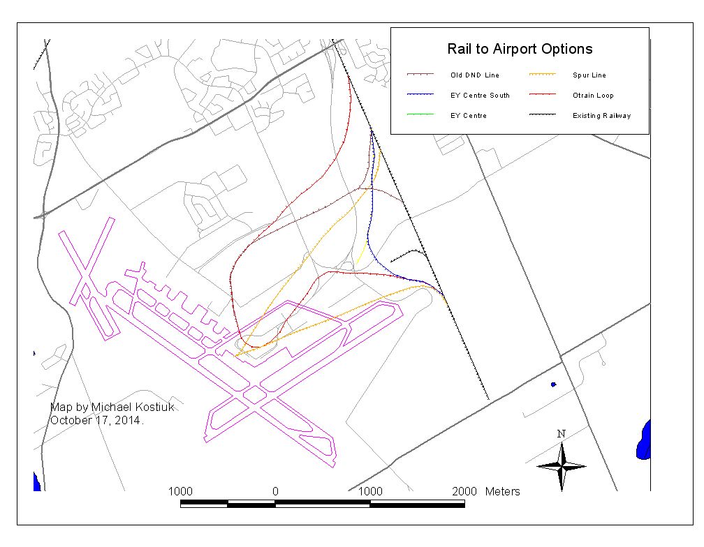
As you can see, most of the routes cross several roads, and they tend to loop in quite a distance from the existing north-South railway line, which lies just to the east of the airport.
Most of the railway lines would in most likelihood require a grade separation in order to get from the existing railway line to the airport terminal. Since there is an aircraft taxiway that serves the National Research Council and RCMP aviation sites it would seem logical that such a separation would need to be a below grade option.
To reduce the analysis to a more manageable scale I have eliminated the lines that cross under the above mentioned aircraft taxi ramp.
Option 1. Former DND Spur Line.
When National Defence operated out of CFB Uplands and later CFB Ottawa there was a rail line that served the fuel tanks near Uplands Drive. At one time it crossed over Uplands Drive into the former base.
The following map shows a spur line using this route.
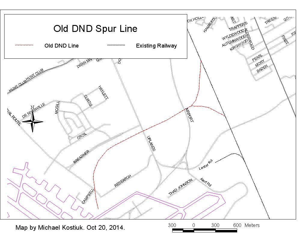
This line would cross over three Roads: the Airport Parkway, Uplands Drive and Paul Benoit Driveway. Such a line could go at grade, however, to make service faster it would most likely have to be grade separated. As well, the train would then need to reverse out from the airport terminal in order to get back to the main North-South railway line. The point where the train connects to the North-South railway line there would be a “Y” junction to allow the train to go either north or south. In order for such a line to be built, its cost would have to be justified in terms of how many passengers would use the train on a daily basis.
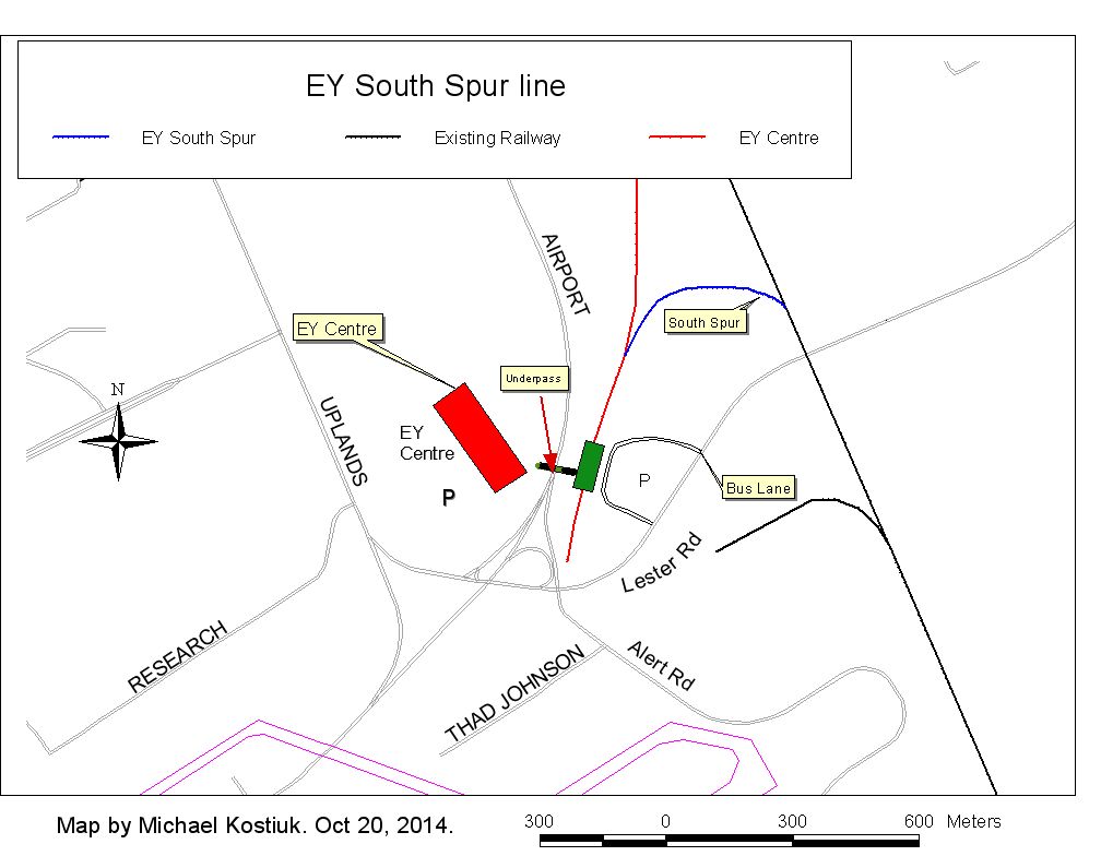
Option 2A. O-Train to EY Centre.
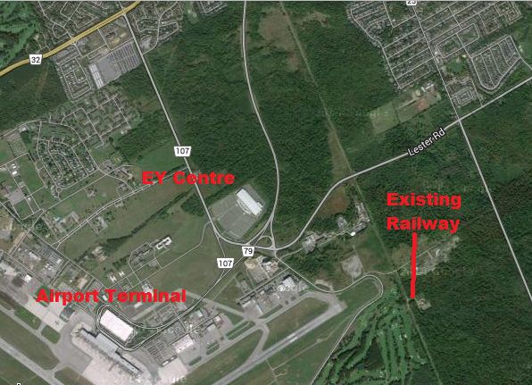
This image comes from Google Maps/Digital Globe/Landsat 2014.
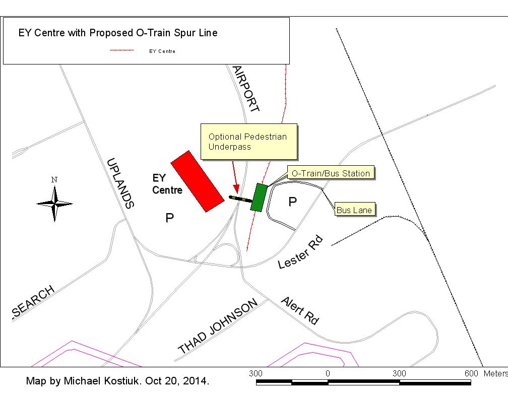
In this scenario a spur line would be constructed from the main North-South railway line just to the east of the Airport Parkway. This Spur Line would then terminate near the intersection of the Airport Parkway and Lester Road. A combination O-Train and Bus Station would be built to allow passengers to transfer to and from the O-Train and buses. There would be a parking lot for commuters, a loop road for buses, and there would be a sidewalk that would allow people to walk to the intersection of Alert and Lester Roads as well as the EY Centre. This is an approximate walking distance of about 900 metres. An optional pedestrian underpass under the Airport Parkway could be built to connect the O-Train Station to the EY centre. The walking distance to the EY Centre would then be approximately 150 metres.
This route does not cross any roads, and it could be build relatively cheaply. The original O-Train cost approximately $4 million per mile and a single track length in this section would be 1460 metres or 0.907 of a mile, or approximately one mile. Other possible costs would be the construction of the Station platform, and the loop road for buses. Options may include a parking lot for commuters, and the pedestrian underpass under the Airport Parkway. This spur line would allow passengers to transfer to a bus that would quickly transport them to the Airport Terminal. Employees who work at the various companies and government agencies on the Airport Lands could also use this transit connection.
Note: The distance from my proposed "E.Y." O-Train Station and the Airport Terminal would be 1.6 kilometres.
Note: The Railway Spur line is shown in green.
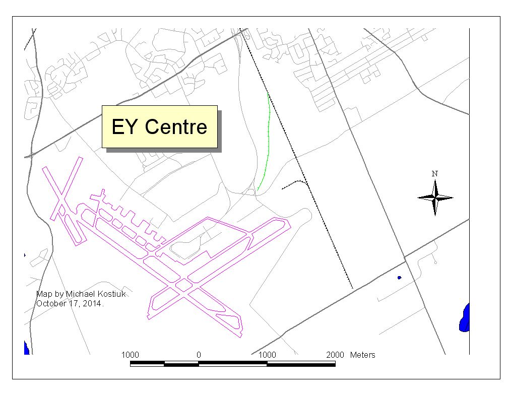
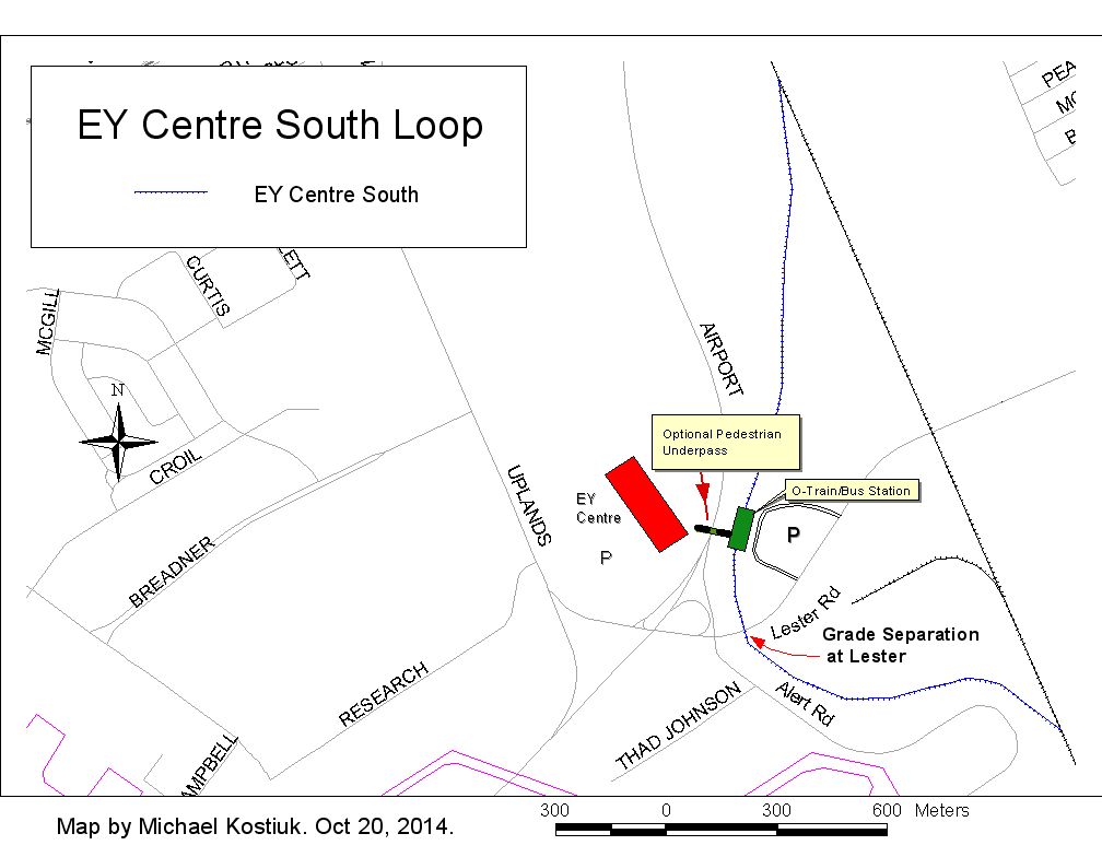
The following map shows a more detailed view of my proposed “E.Y.” Station.
Option 2B. Reconnecting Spur Line to the main North South Line.
This option is the same as option 2A except that it also has a spur line, which allows a southbound connection to the main North-South railway line. The length of this additional Spur Line is approximately 470 metres. This would allow an O-Train to go south across Lester Road towards Leitrim Road and further south.
Option 3C. EY Loop Line.
This option uses the same line as Option 2A to get to the "E.Y." O-Train Station, but instead of using a Spur line to get back to the Road Crossing at Lester it would instead go under Lester Road and loop around Alert Road to join the existing North-South Line just south of Lester Road. This is the most expensive of the “E.Y.” routes since it requires a below road grade separation. It would also be built to a two-track design for future expansion. One of the advantages of this option is that all north and southbound trains would serve the EY Centre and the Airport Lands as part of their regular route. The grade separation would also increase train speeds and reduce traffic delays on Lester whenever an O-Train crossed the road.
The following map shows this option.
Conclusion.
The above options show that the most practical and cost effective way to bring an O-Train near the Ottawa Airport, which would also serve the “EY” Centre is Option 2A.
This option also allows for two types of future expansion routes to connect to the southbound railway line.
My goal of this exercise was to look at cost effective ways to bring the O-Train close to the Ottawa Airport. In these times of concern about over spending I believe that this Transit option is one worth considering for the people of Ottawa.
Michael Kostiuk
Candidate for City Council. River Ward (16).
michael@michaelkostiuk.com

Comments
Be the first to comment